
Softengi has developed a portal of the Unified Complex Monitoring and Forecasting System (UCMFS) on request of the Ministry of Emergency Situations of the Kyrgyz Republic sponsored by the World Bank.
The web platform solution is a complex geo monitoring and forecasting tool, which enables specialized authorities to share valuable information, forecast natural hazards, and cooperate in the research and the event of an emergency.
The Kyrgyz Republic has a very complex terrain and variable weather conditions, both of which contribute to the natural calamities. To meet this challenge and proactively act on environmental hazards, we have developed a joint web platform solution that allows to constantly monitor hazards, perform high-quality research, and collaborate more closely with various institutions.
This was quite a challenging task, as weather conditions are very volatile and fickle, so Softengi had to put much effort into developing a web platform solution that could successfully handle both climatic and terrestrial conditions, providing qualitative and quantitative data on hazards in advance in order to assess upcoming events.

Main Functions of the Web Solution:
A portal of the Unified Complex Monitoring and Forecasting System (UCMFS):
- Provides the public and authorities with information about potentially dangerous natural and technogenic processes in Kyrgyzstan;
- Ensures that qualitative and quantitative information on environmental risks is obtained in advance;
- Reduces the time spent on obtaining the necessary information by EMERCOM and other platform participants;
- Provides assessment of complex and potentially dangerous situations;
- Intensifies cooperation of national authorities in managing natural hazards.
Technologies used:
- GeoServer, for collection, storage, and publishing of geoinformation at the administration level;
- GeoNode, for storage and management of geoinformation at the user level;
- AGORA (Communication & Collaboration Platform) for managing the structure and content of the Public Portal;
- Logstash, for collecting and processing external sources data (data from measurement stations, warning systems);
- Metabase, for visualization of statistical data in the form of tables and diagrams. Ability to place generated reports on external resources.
How Does It Work?

To ensure efficient monitoring of hazards and natural conditions, we integrated constant data inflow from external national and global sources that provide information on national hydrometeorological, hydrological, radiation conditions, as well as data on forest fires, earthquakes, as well as movements of terrestrial masses.
- Data from specialized monitoring services, research institutes, and organizations specializing in monitoring and predicting hazardous processes using OGC services;
- Processed data from measuring stations, networks of automatic monitoring of the natural environment;
- Data from global monitoring and forecasting resources provided in OGC standards;
- Satellite imagery from international data centers.
The web platform solution is a kind of information space divided into two blocks: one for public use, the other one can only be accessed by authorized users, namely, various specialized organizations, authorities, and research institutions.
Public Information Portal
The Public Information Portal is an important part of the system, it is used to inform the general public about dangerous natural processes and emergencies. The portal is available for all users and contains information generated by ESCMP members.
The Public Information Portal:
- Shows data on natural hazards and emergencies;
- Monitor processes;
- Shows spatial data on natural hazards;
- Shows observation data and data generated by monitoring stations;
- Notifies users about emergency situations.
The portal offers a structured catalog of hazards containing a detailed description of each hazardous process. Users can learn about the causes of natural emergencies, their activation specifics, development parameters, and advice on how to behave in this event.
Information Platform
The information platform was more complex in development as it manages the whole information flow, analyzing the incoming data and providing on that basis accurate forecasts. Only authorized users have access to this block. The solution is available on any device via a web browser.
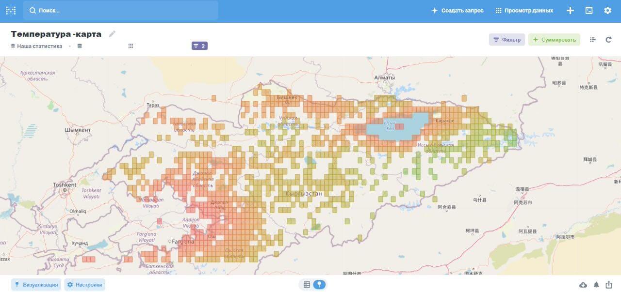
Maps
In addition, the portal has a real-time map that shows the locations of hazardous processes, allowing users to view hazardous areas. Built-in predictive tools allow the portal to provide forecasts on natural conditions, thereby preventing residents from entering danger zones and thus avoiding accidents. Moreover, users can report observed threats on-site by filling out an application on the portal.
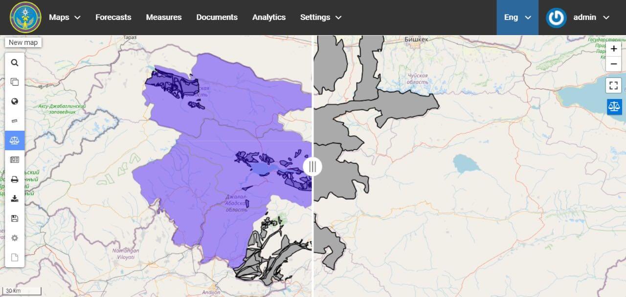
The Information Platform offers a set of map-handling tools. Users can upload any map and process it in different ways, change the base layer, overlay a map layer on top of the base model, meter areas, and mark certain high-risk locations. We also developed a tool to visually compare multiple map layers. As a result, research institutions and specialized organizations can directly perform research and show their results on the platform.
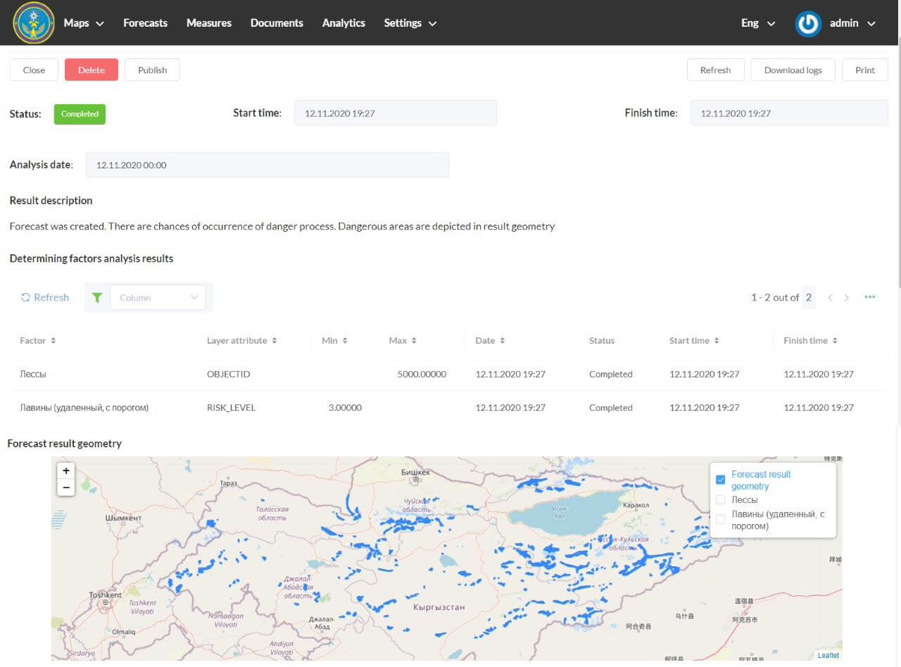
Forecasting
Certain natural hazardous events occur under the influence of various factors such as wind fluctuations, humidity, climatic conditions, etc. We have developed tools that take into account all external factors and determine the probability of a particular event to happen, detecting their occurrence areas. In addition, users can request a forecast setting thresholds for the determining factors themselves.
Data Management
The information platform offers centralized document storage, where users can upload their documents, for instance, research results, digitize existing records, create documents using templates, and display saved data on maps.
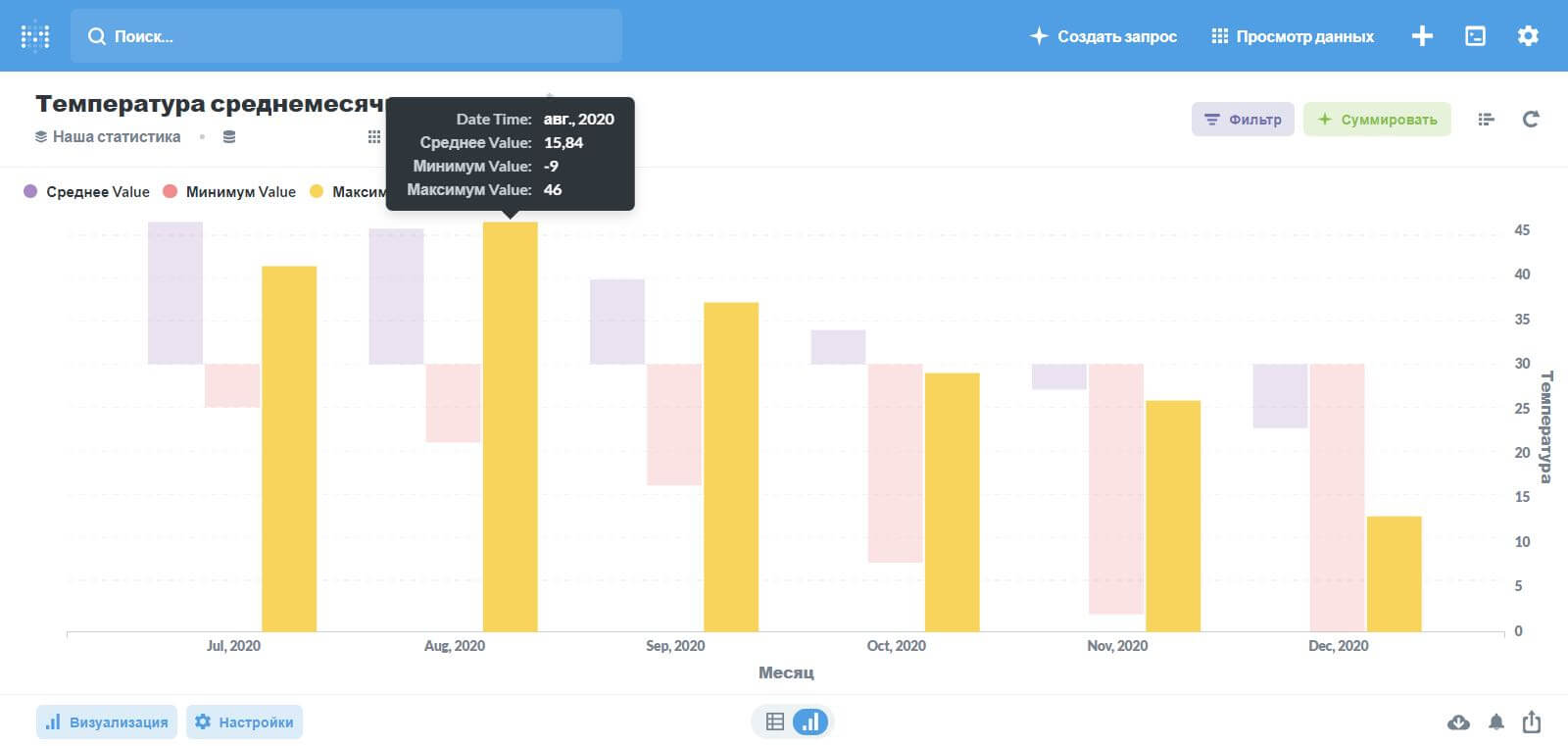
Analytics and Visualisation
In-built analytics allows to easily analyze internal and external data, providing users with user-friendly reports. The gained information is then visualized in charts and graphs to enable users to easily review complex content.
Benefits of the Web Platform Solution
There are numerous observable benefits of the web platform:
Enhanced Collaboration
The joint access and advanced mapping tools on par with data analytics and forecasting capabilities allow authorities and research organizations to collaborate more efficiently and enhance their joint research.
Reduced Accidents
The complex monitoring of environmental conditions helps the Kyrgyz Republic to reduce the overall number of accidents due to natural hazards.
Secured Data
The web platform solution offers secured data management, so the document flow and storage are protected from external security threats.
Decreased Costs and Time on Research
Real-time monitoring and advanced research tools allow various institutions to perform high-quality collaborative research, which, as a result, leads to reduced costs and time, as conducting research independently is much more resource-consuming.
PEOPLE ALSO READ

AI-Powered Permit Analyzer for Regulatory Compliance
Softengi developed an AI application that streamlines the review of complex permit documents.

Universal Data Lake Publishing Service for Large-Scale Data Publishing
Softengi successfully implemented a data lake publishing solution that addresses EHS vendor's critical data transfer challenges.

Mental Well-Being Clinic for Virryhealth
Softengi developed a virtual clinic with interactive and non-interactive activities where visitors could schedule therapy sessions with medical experts and visit a VR chat in the metaverse to interact with the amazing nature and animals of the African savanna.